The world is a busy place, with politics changing and events happening all the time. However, we make it simple to quickly read all the pertinent data for every country, in addition to flag details and an atlas summary for what kind of general information you are most interested in Nepal.
The following basic facts and information are covered in detail in each Country’s Profile:
Maps, geography, Brief history, the current ruler, area, population, capital, and largest cities – Languages-Race and ethnicity – Faith – Rate of literacy and The economy.
Facts & Information about Nepal
LetsExplore has everything you need to know about Nepal. Check out our country profile, full of essential information about Indonesia’s geography, history, government, economy, population, culture, religion, and languages.
Flag Of Nepal

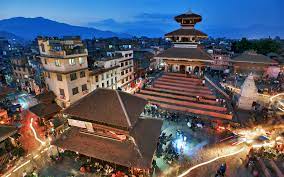
Map Of Nepal

President: Bidhya Devi Bhandari is the president since 2015.
Prime Minister: Sher Bahadur Deuba is the prime minister (2021).
Area: 55,348 square miles (143,351 square kilometers) of land; 56,826 square miles (147,181 square kilometers) of total area; 1,478 square miles (3,830 sq km) of water
Population: Population estimates for 2022 are 30,666,598 (growth rate:.78). Life expectancy is 72.4 years; birth rate is 17.53 per 1000; infant mortality is 25.13 per 1000.
Capital: and largest city (estimated for 2011): 1.521 million Kathmandu
Other big cities: Lalitpur, 169,100; Biratnagar, 174,600
Currency: Nepalese rupee
Languages: Urdu 2.6%, Avadhi 1.9%, Limbu 1.3%, Gurung 1.2%, other 10.4%, unidentified 0.2%, Maithali 11.7%, Bhojpuri 6%, Tharu 5.8%, Tamang 5.1%, Newar 3.2%, Magar 3%, Bajjika 3%, and Nepali (official) 44.6% Note: The 2011 National Census revealed 123 languages as mother tongues; many people in industry and government also speak English (2011 est.)
Race and ethnicity: Muslim 4.4%, Yadav 4%, Rai 2.3%, Gurung 2%, Damai/Dholii 1.8%, Thakuri 1.6%, Limbu 1.5%, Sarki 1.4%, Teli 1.4%, Chamar/Harijan/Ram 1.3%, Koiri/Kushwaha 1.2%, other 19%. Chhetri 16.6%, Brahman-Hill 12.2%, Magar 7.1%, Tharu 6.6%, Tamang 5.8%, Newar 5%, Kami 4.8%, Muslim 4.4%, Yadav 4% Note: The 2011 national census (2011 est.) identified 125 caste/ethnic groups.
Religions (2011 est.): 1.4% Christian, 1.4% Buddhist, 4.4% Muslim, 3.1% Kirant, 81.3% Hindu, 0.5% other, and 0.2% unspecified.
Literacy Rate: The estimated 2018 literacy rate is 67.9%.
Economic Summary:
GDP/PPP (estimated for 2020):
$110.72 billion; $3,800 per person. The real rate of increase is 7.9%. 2017 inflation was 4.5%. Jobless rate: 3% (estimated for 2017). 15.1% of land is arable.
Agriculture: water buffalo meat, milk, rice, corn, wheat, sugarcane, and root crops. Workforce: 16.81 million; note: serious shortage of trained workers (estimated for 2017); services make up 19%, industry 12%, and agriculture 69%.
Industries: Industries include tourism, textiles, carpets, small-scale rice, jute, sugar, and oilseed mills; the manufacture of cigarettes, cement, and bricks. Natural resources include lignite, modest quantities of copper, cobalt, and iron ore, as well as quartz, water, timber, hydropower, and scenic beauty. Exports: $1.79 billion (estimated for 2020): apparel, carpets, jute products, leather items, and grains. Principal export trading partners: 10% US, 68% India (2019). $10.68 billion (estimated) in imports, consisting of fertilizer, petroleum products, machinery, and gold. India and China are the two main trading partners (imports) as of 2019.
Communications: 726,000 primary phone lines were in use in 2020; 38.213 million mobile phone lines were in use. The state runs three television stations and several national and regional radio stations. Of the 117 television channels that are licensed, 71 are cable channels, three are distributed via the Direct-To-Home (DTH) system, and four are distributed digitally terrestrially. Of the 736 FM radio stations that are licensed, at least 314 are community radio stations (2019). 41,256 hosts are online (2012). 11,071,987 people use the internet (2020).
Transport: Railways: 59 kilometers in total (2018). 27,990 km of roads, 11,890 km of paved roads, and 16,100 km of unpaved roads (2016). Harbors and ports are absent. 47 airports as of 2021.
Geography:
Nestled between India and the Tibetan Autonomous Region of China, Nepal is a landlocked nation the size of Arkansas that is home to the world’s tallest mountain, Mount Everest (29,035 feet; 8,850 meters). There is a level stretch of partially forested, partly cultivated territory that runs along Nepal’s southern border. The major Himalayan range, which includes Everest and numerous other peaks above 8,000 meters, slopes north of that.
Government Type:
King Birendra proclaimed a new constitution in November 1990, ushering in a multiparty parliamentary democracy in Nepal. King Gyanendra relinquished direct rule and restored Parliament in response to demand during the enormous pro-democracy rallies in April 2006; Parliament then promptly took steps to curtail the King’s authority. Parliament decided to end the monarchy and establish a federal democratic republic in December 2007. Once the Constituent Assembly decided to abolish the monarchy in May 2008, the country’s transition to a republic was complete.
History:
During the 6th century B.C., Nepal’s first civilizations emerged, but they were limited to the lush Kathmandu Valley, which is home to the country’s modern capital. Prince Siddhartha Gautama was born in this area in 563 B.C. As the Buddha, Gautama attained enlightenment and gave rise to Buddhism.
The early support of Buddhism by Nepali monarchs was completely replaced by Hinduism in the 12th century, a reflection of India’s growing power. Even though the Gopala, Kirati, and Licchavis kingdoms all extended their dominion, Nepal did not take on the general dimensions of the present state until the Malla rulers ruled from 1200 to 1769.
King Prithvi Narayan Shah, who had fled India after the Moghul conquests of the subcontinent, united the kingdom of Nepal in 1768. Nepal’s borders grew as far west as Kashmir and east as Sikkim (now a part of India) under Shah and his successors. Following more than a year of fighting with the British East India Company, a commercial pact was concluded with Britain in 1792 and again in 1816.
You can also check Country Of The World – Sri Lanka here!
Leave a Reply