The world is a busy place, with politics changing and events happening all the time. However, we make it simple to quickly read all the pertinent data for every country, in addition to flag details and an atlas summary for what kind of general information you are most interested in.
The following basic facts and information is covered in detail in each Country’s Profile:
Maps, geography, Brief history, the current ruler, area, population, capital, and largest cities – Languages-Race and ethnicity – Faith – Rate of literacy and The economy.
Facts & Information about Malaysia
LetsExplore has everything you need to know about Malaysia. Check out our country profile, full of essential information about Malaysia’s geography, history, government, economy, population, culture, religion, and languages.
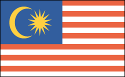
Flag Of Malaysia

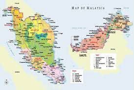
Map Of Malaysia

- Head of State: Sultan Muhammad V (Since 2017)
Prime Minister: Dr. Mahathir bin Muhamad (Since 2018)
Land area: 126,853 sq mi (328,549 sq km); total area: 127,316 sq mi (329,750 sq km)
Population (2014 est.): 30,073,353 (growth rate: 1.47%); birth rate: 20.06/1000; infant mortality rate: 13.69/1000; life expectancy: 74.52
Capital and largest city (2011 est.): Kuala Lumpur, 1.556 million
Other large cities: Klang 1.19 million; Johor Bahru 1.045 million (2011)
Currency: Ringgit
Languages: Bahasa Melayu (Malay, official), English, Chinese dialects (Cantonese, Mandarin, Hokkien, Hakka, Hainan, Foochow), Tamil, Telugu, Malayalam, Panjabi, Thai; several indigenous languages (including Iban, Kadazan) in East Malaysia
Ethnicity/race: Malay 50.1%, Chinese 22.6%, indigenous 11.8%, Indian 6.7%, other 0.7%, non-citizens 8.2% (2010 est.)
Religions: Muslim (official) 61.3%, Buddhist 19.8%, Christian 9.2%, Hindu 6.3%, Confucianism, Taoism, other traditional Chinese religions 1.3%, other 0.4%, none 0.8%, unspecified 1% (2010 est.)
National Holiday: Independence Day/Malaysia Day, August 31
Literacy rate: 93.1% (2010 est.)
Economic summary:
GDP/PPP (2013 est.): $525 billion; per capita $17,500. Real growth rate: 4.7%. Inflation: 2.2%. Unemployment: 3.1%. Arable land: 5.44%. Agriculture: Peninsular Malaysia—rubber, palm oil, cocoa, rice; Sabah—subsistence crops, rubber, timber, coconuts, rice; Sarawak—rubber, pepper, timber. Labor force: 13.19 million (2013 est.); agriculture 11.1%, industry 36%, services 53.5%.
Industries: Peninsular Malaysia: forestry, oil palm, and rubber processing, electronics, light manufacturing, tin mining and smelting, and timber processing; Sabah: extraction of petroleum and logging; Sarawak: logging, petroleum production and refining, and agricultural processing.
Natural resources: tin, petroleum, timber, copper, iron ore, natural gas, bauxite.
Exports: $230.7 billion (2013 est.): electronic equipment, petroleum and liquefied natural gas, wood and wood products, palm oil, rubber, textiles, chemicals.
Imports: $192.9.4 billion (2013 est.): electronics, machinery, petroleum products, plastics, vehicles, iron and steel products, chemicals.
Major trading partners: U.S., Singapore, Japan, China, Hong Kong, Thailand, South Korea, Indonesia, India, Australia (2012).
Member of the Commonwealth of Nations
Communications: Telephones: main lines in use: 4.589 million (2012); mobile cellular: 41.325 million (2012). Broadcast media: The nation’s top private commercial media conglomerate runs four TV stations with many relays across the nation, while the state-owned TV broadcaster runs two TV networks; There are several private commercial radio broadcasters, some subscription satellite radio services, a state-owned radio broadcaster operating numerous national networks in addition to regional and local stations, and a total of approximately 55 radio stations (2012). Additionally, satellite TV subscription service is offered. Internet Service Providers (ISPs): 422,470 (2012). Internet users: 15.355 million (2009).
Transportation: Railways: total: 1,849 km (2010). Roadways: total: 144,403 km; paved: 116,169 km (including 1,821 km of expressways); unpaved: 28,234 km (2004). Waterways: 7,200 km (Peninsular Malaysia 3,200 km, Sabah 1,500 km, Sarawak 2,500 km). Ports and harbors: Bintulu, Johor Bahru, George Town (Penang), Port Kelang (Port Klang), Tanjung Pelepas. Airports: 114 (2013).
Geography
Malaysia is located in Southeast Asia on the Malay Peninsula. Sabah and Sarawak, located on the eastern island of Borneo, are also part of the nation. Its area is marginally larger than New Mexico’s.
The majority of Malaysia is covered in forests, and the peninsula is dotted with mountains. Teak, sandalwood, ebony, and other woods are found in extensive forests.
Government Type: Constitutional monarchy.
History
Between 2500 and 1500 B.C., the ancestors of the people who currently live on the Malaysian peninsula originally moved to the region. Early interactions between Chinese and Indians were experienced by those residing in coastal areas; Hinduism was introduced by Indian maritime traders and assimilated with indigenous animist ideas. Following their conquest of India, Muslims introduced Islam to Malaysia. Islam solidified its hold on the region in the fifteenth century with the conversion of Parameswara Dewa Shah, the Hindu ruler of the influential city-state of Malacca.
Following the British East India Company’s construction of a commercial settlement on the island of Singapore in the 1800s, interest in the area increased among the British and Dutch. Trade flourished, and in just 50 years, Singapore’s population increased from 5,000 in 1820 to approximately 100,000. Malaysia was technically under British protectorate rule in the 1880s. Rubber trees were imported from Brazil in about the same period. With the mass production of automobiles, rubber became a valuable export, and laborers were brought in from India to work the rubber plantations.

Leave a Reply